By:
Category:
Comments Off

Skiing & tubing


While most folks were watching the Super Bowl we went to Powder Ridge to play in the
snow. Cristy & Jacob went skiing (no pictures.) Ben, Joe, and I went tubing.


It is kind of hard to take pictures going down the hill on a tube  when it is
dark. I was surprised that I even got these with the little camera.


By:
Category:
Comments Off

Snowy Train


I have not posted many nontechnical photos this winter.  I took this train
photo back in December 2008 some time but had not gotten around to posting it.


This is the BNSF rail line that runs parallel to MN State Highway 12 in Dassel.


I have been holding out hope that I was going to get some cool winter pictures of
the trains going through deep snow out in rural Minnesota. So far this winter that
has not been reality for me... yet. We are heading into what is typically the
snowiest part of our winter season.  --Fingers Crossed!


By:
Category:
Comments Off

MNQRP Club - Jan 2009 Meeting


Some pictures from the Jan 10th 2009 Meeting.


I have some more pictures beyond these but this is a pretty long posting already.
It was a fun meeting with a lot of show and tell and pass around items.


Link to our club's website:

http://www.mnqrp.org/


Link to some of the topics and items that were shared:

http://cbjohn.com/aa0zz/index.html


http://www.kangaus.com/


http://www.qrpkits.com/files/MiniSolderPot.pdf


http://www.ohr.com/wattmeter.htm


http://www.norcalqrp.org/nc2n2xx.htm


By:
Category:
Comments Off

Updated - Mio Moov 200 - Geocaching


Here is the modified CSV file that I am working with:


I ended up using the Spreadsheet app within OpenOffice to create some additional columns
and copied in the proper field names. This allowed me to create an XML format within
the CSV file. I then opened up the CSV file with with a text editor and ran a couple
find/replace commands to remove the commas and reformat some white space.


I then copied this XML and inserted it into: MyFavouriteLocations.xml


Initially the file was so big that the GPS kept crashing and rebooting. I then trimmed
down the size of the file by removing some cache entries. I cut it roughly in half
and that was enough to get it working. There are probably some extra lines in each
entry that could be trimmed back some more. I have been working on trying to figure
out which lines are required to make this work.


Another hint.... you can't have "&" in the XML. That will potentially
break some of the XML parsers. I was using IE to preview/test my XML and ran into
that issue for 3-4 of the entries.


I now have 100-200+ caches loaded in as favorites. It is not as nice as having them
in the POI database... but it is a start. This only took about 15-20 minutes. Not
as cool as a parsing engine... but functional for a once in a blue moon event.


Here is the XML format that you need:


By:
Category:
Comments Off

Hacking the Mio Moov 200 for Geocaching


My son got a Mio Moov 200 for a Christmas gift. He is interested in Geocaching and
wants to be able to use this device for the hunt. After quite a bit of searching
I am not seeing much success from others.


The Mio Moov 200 appears to be an ARM processor running Windows CE. You can mount
the GPS as a USB drive you can browse the filesystem. At the root I found some text
and XML file with the following info:


Created: 2008-02-18 18:42:34:968750000

Software: COBIA_300_64_NA 5.50.0023

Map Data:TA_NA_0710_3207

Map Region:US

Part Num: 565116840019R02 


[Process1]

RelativePath=TRUE

ProcessFile=SmartST_CE.exe

ProcessCmdLine=

ProcessDbgFile=SmartST_CEDbg.exe

ProcessDbgCmdLine=

MaxRestarts=3

Major=TRUE

WindowName=SmartST_CE

MaxCloseMessages=10


The older units used to use an iGO format and there are conversion tools for that
format. Based upon some notes that I found on the Internet it appears the Mio purchased
a company called Navman and adopted their tools. That is unlucky for us it because
it appears that no one has built a tool to import geocaching info into their
POI database.


Their is a rumor that the POI database is based upon SQLite but I am unable
to confirm that because I have been unable to find the database. Other folks
report that it is named database.db but I can't find that on my GPS. Since I
am unable to find a POI file or database I decided to try another route. 


Once of the interesting things about this GPS is that it has a LOT of XML files. Almost
all of the config is XML. Open up the following file with notepad or some other
editor:

I:\Program Files\Navman\SmartST_CE\UserData\MyFavouriteLocations.xml


It is possible to modify this file to include your Geocache location. But it requires
hand formating some XML.


I converted a GPX file from www.geocaching.com Pocket
Query into a CSV text file via another website called GPS
Visualizer
. I then reformatted the latitude and longitude in formation so that
decimal point was removed. Now at this point to can manual create/insert some XML
into: MyFavouriteLocations.xml


Here is an example of what I created:


I had to reformat some of the original XML to make it more readable in my browser
and editing tools. After a couple of attempts I was able to get a file that worked
as designed showed up  and showed up as a favorite. So far I have about 3 hours
into this little experiment in an attempt to make my son happy. (We have other
GPS that I can upload cache locations into... but this is HIS gps.)
I am not
sure how many favorites this little device will hold at this point.


I really need to come up with a simpler way to format the XML so that I can insert
one large block here. A more advanced person could probably whip up a script
to do this or push it into a SQL formated RDMS and then run a query that formats the
output data.


Hmmm... I am not sure what is next. All that I know is that I hate Mio Moov 200. This
is a lot of work to navigate to a parking location just so that I can then get out
my 10+ year old Garmin 12 to hike in.


I have about 500 locations loaded into my TomTom One and Garmin 12 at this point in
less than an hour. That time includes also figuring out how to format the data and
run the various tools. I can now load about 500 locations into both of them in less
than 10 minutes.


By:
Category:
Comments Off

Geocaching with Garmin 12


Using the GPX file from the earlier blog posting I was able to get it loaded into
my Garmin 12 gps. This GPS is pretty old but extremely reliable.


I downloaded the eval edition of GeoBuddy from:

http://www.geobuddy.com/


It is a pretty neat program while pull up the details and maps for each cache as you
click on them. It is also design to track and update you info on www.geocaching.com.


Right now I was just looking for an easy to load the data into the Garmin 12. The
only magic was that I had to the change the "Interface" options on the GPS so that
it would look like a Garmin host. I am not sure why is it will accept NMEA sentences
directly. --Whatever... I was able to push the data to the GPS.


I am still considering what tool I am going to use on an ongoing basis. I would prefer
a free or open source tool and I don't really need this many features. If I can't
find a simpler/cheaper tool I will spend the $49 to buy this one.


I would prefer to use something open source since for the GPS 12 since I will probably
end buying a BlackBerry with GPS and then end up buying the Geocaching software on
for the crackberry.


For a 10+ year old GPS it still does a pretty good job. It is incredibly rugged which
is a requirement when you have 6, 8, and 10 year old kids hiking with it.


By:
Category: ,
Comments Off

GeoCaching notifications on your TomTom One


It is nice to get notifications when you driving near some geocaches with the kids
in the car while running errands. Here are the steps for setting up the notifications.


Go into the preferences and select "Warn when near POI"


Select your category.


I see mine to notify me of them if we are within 5 miles.


Choose a sound.


Yes


I chose no... I want it warn all the time.


You are done.


By:
Category: ,
Comments Off

Geocaching with a TomTom One


Here are some simple notes on how to download GeoCache locations into your TomTom
One 3rd Edition. It took me about an hour to figure this out the first time. It is
similar for other platforms.


I upgrade my account at www.geocaching.com free
a Free account to a Premium account. This makes easier to run large queries for
sites. You can use the free account but the number of sites that you download in a
single run is smaller, you will only be able to use the *.loc format, you can't setup
pocket queries, our trips. (Spend the $30... it is well worth the money for the features.)


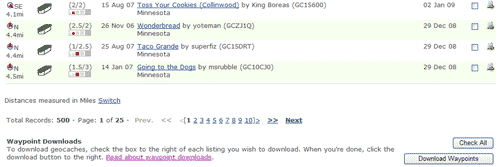
The free search will give you something like the picture below. Select which caches
you want and click "Download Waypoints" and you will be prompted to save a *.loc file.


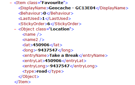
If you have a Premium account you can build a Pocket Query and then select when you
want it to run. I a couple of minutes later you will get an email. The picture below
was my first query.


I then went to:


http://www.gpsvisualizer.com/gpsbabel/gpsbabel_convert?all_types=1&intype=gpx&outtype=tomtom&type=w&zip_output=0


That link will set it up for GPX and TomTom file formats. It will also support the
*.loc format if yo choose that from the menu.


FYI... The TomTom One uses a *.ov2 format

Browse to your source file that you saved or got via email.


Click "Convert the file"


Once the processing is done the web page will refresh and you will get a link to down
load your file. Go ahead and download the file and save it someplace where you will
not lose it.


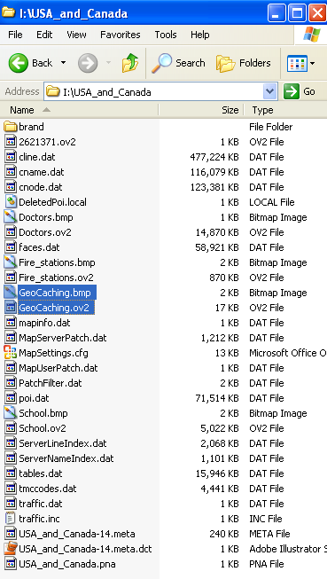
I renamed the file that we just downloaded to: GeoCaching.bmp


I then created a 22x22 8bit bitmap image for the icon that will show up on the map.
I saved it as GeoCaching.bmp.  (Right
click on this bmp and save it.)


These two files need to have the same name with their respective file extension. I
put both files into a new directory on my local pc. Your mileage may vary.


I then connected my GPS to my laptop/pc via the USB cable. You will be able to browse
the directories just like a USB hard drive or thumb drive. In my case the GPS shows
up as my I:\ drive. Browse to I:\USA_and_Canada. You will now copy the two files GeoCaching.ov2
and GeoCaching.bmp into this map directory.


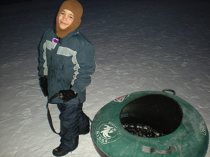
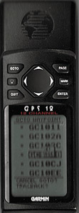
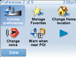
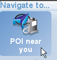
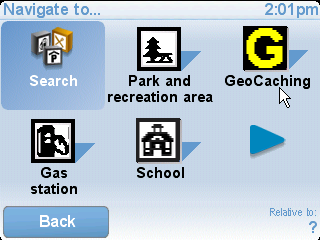
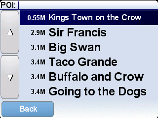
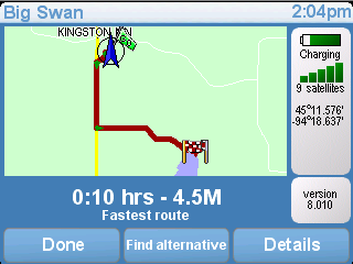
Disconnect the USB cable from the GPS and you should now be able to browse GeoCaches
as POI. The pictures below summarize browsing to a GeoCache POI assuming that
you understand the basics of the TomTom menus.


The TomTom runs Linux and appears to be a very hackable little device. These instructions
might make this look like a big process which is not really the case. Once you have
done it once you can actually do the whole process in about 5-10 minutes.